Cold War’s Cold Legacy: Soyang Multipurpose Dam, the Local Environment, and Envirotechnical Development in South Korea
Technology’s Stories vol 8, no. 3 – DOI: https://doi.org/10.15763/jou.ts.2021.01.05.01
On August 25, 1995, my family drove uphill, in the pouring rain, towards the Soyang Multipurpose Dam. We planned to watch the spectacle of water being discharged from three flood gates of the largest rock-fill dam in East Asia. With the water level reaching just a few meters short of its maximum, and with tropical storm Janice approaching, the Korea Water Resources Corporation had decided to open the flood gates to discharge water at the rate of 3,800 tons per second. The dam was designed to provide 200-year flood protection, but this was the tenth time flood gates had been opened since the dam’s completion in 1974. This fact did not bother the hundreds of people, including my family, who gathered to watch this rare event. Mainstream newspapers, too, described it as a “magnificent view” created both by an unruly weather event and a marvelous human creation.[1]
The Soyang Multipurpose Dam has been hailed as one of the most outstanding engineering achievements in modern Korean history. For instance, in their recent publication on the history of industrial technologies in South Korea, the National Academy of Engineering of Korea took on a nationalistic tone in its appraisal of Soyang as a: “magnificent dam … constructed by our own technologies and own hands in the economically deprived period of the early 1970s.” This essay explores the story of the Soyang Multipurpose Dam to consider the material implications of envirotechnical developments. Scholarship at the intersection of the history of technology and environmental history has explored the dynamic ways in which the environment and technology are mutually shaping. Dams are the most representative envirotechnical systems where the environment and technology are inseparable, physically, and analytically. A closer look at the dam’s environmental impacts brings previously undermined tensions between the national developmental project and local experiences to the fore.
This history will follow an unexpected byproduct of the dam: cold water. In deep lakes, water becomes stratified into layers based on their different temperatures. Below the thermocline, where a steep temperature drop occurs, the water temperature stays low and constant over the year. In Soyang Lake, about 500 million tons of cold, deep lake water is produced annually. Around 4-5 million tons of this cold water (at 5-6°C or 41-42.8 °F) is released downstream every day after being used for power generation. The release of this cold water affects the micro-climate, winter landscape, and agriculture and fisheries of the region. In this context, coldness is not a purposeful technological production as seen in the studies of air conditioning, sperm and egg preservation, seed vault, or ice-core samples for climate research. Instead, it is a form of thermal pollution created by envirotechnical developments. This pollution in turn has made notable physical changes to the local environment and to the ways that local people interact with the river.
A Cold War Product
The Soyang Multipurpose Dam (1967-1973) was constructed within the shifting geopolitical relationships of the Cold War. Mobilization of engineering expertise, financing, and design all illustrate how Cold War ideologies shaped the dam’s materiality – its physical structure and its relationship to the local environment. The U.S. provided critical technical consultation on water resources management and dam construction. Plans to construct a dam on the Soyang River were first discussed in the 1950s, as a way to manage the Han River’s water resources. But it was in the 1960s when American consulting firm Smith Hinchman-Grylls conducted the feasibility study that the plan started to take shape. In 1966, the Han River Basin Joint Survey Team, co-organized by the Ministry of Construction of South Korea and the United States Operations Mission (USOM), suggested constructing a multipurpose dam to maximize water resources.[2] These studies provided the scientific and economic rationale to build an ambitious dam, which at the time some considered too large in capacity and too challenging to construct.
Japan became involved as well, a move that was possible because of changing geopolitics. With the Treaty of San Francisco of 1951, Japan had re-established a peaceful relationship with the Allied countries. With South Korea, a new diplomatic relationship signed in 1965 came with a property claim against Japan. According to this treaty, Japan would provide about 36% of the budget for constructing the Soyang Multipurpose Dam. Japanese engineering consulting firm, Nippon Koei, also provided the key technical expertise for planning and designing the dam, although its original proposal changed as construction began.[3] Nippon Koei’s involvement was a part of its attempts to rebrand itself from the major player of Japan’s colonial infrastructure development to a specialist in international development during the Cold War.[4]
A final geopolitical consideration was the situation with North Korea, as the possibility of an attack on the dam was one of the criteria in deciding the dam’s design. Located only 12 km (7.5 miles) away from the Demilitarized Zone (DMZ) with a watercourse directly connected to the capital city, bombing the gigantic dam would be catastrophically damaging. Thus, it was important to design a dam that would minimize the damage that a possible attack could produce. Japanese and Korean engineers had different ideas as to which design would be suitable. In their proposal, Nippon Koei suggested that a concrete dam would be less damaging and easier to repair in the case of bombing. A concrete dam would also be beneficial in supporting domestic concrete production. By contrast, Hyundai Construction, a Korean company that carried out the project, proposed a rock-fill dam. With a rock-fill dam, it argued, downstream cities would be better protected if bombed, and the cost of construction would be reduced using rock and gravel from nearby mountains. After the military evaluated the two designs in terms of national defense, South Korean officials decided to build a rock-fill dam.
The dam was expected to bring industrial prosperity to the country, especially by supporting urban and industrial developments in Seoul and the surrounding regions. The brochure introducing the project made this point clear. The dam had three purposes: preventing damage from yearly flooding, meeting rapidly increasing electricity needs, and increasing the water supply for domestic, industrial, and agricultural uses in the immediate region of the national capital at Seoul.[5] The construction of the Soyang Multipurpose Dam was an essential part of the First Comprehensive National Physical Development Plan (1972-1981) of South Korea. Indispensable to the success of the authoritarian military regime of PARK Chung Hee (1963-1979), the plan laid out specifics for “efficient land use and management,” including transportation, industrial parks, and power networks. The key philosophy was a division of labor; the land would be functionally divided and ordered to most effectively contribute to the national economy.[6]
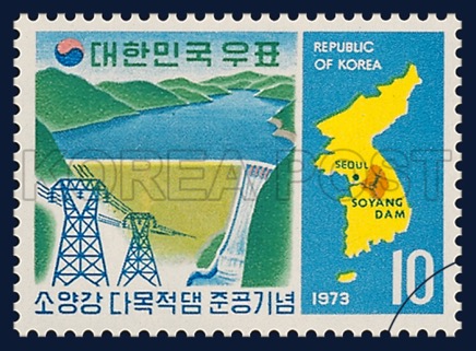
According to this comprehensive development plan, the role of Soyang Multipurpose Dam and its water basin was focused entirely on providing resources for the growing nation’s capital. A commemorative stamp illustrates well how the dam and the localities were placed in the national plan. (See Figure 1). An envirotechnical system consisting of abundant water, a gigantic dam, and transmission towers were portrayed as only meaningful in terms of their effect on Seoul. For those living in the area close to the dam, however, the consequences of dam construction were damaging, and far from trivial.
Figure 1: Commemorative Stamp celebrating the completion of Soyang Multipurpose Dam, 1973. (Office of Postal Service Korea)
The suffering of the local people shows this. The dam’s construction caused 2,703 square kilometers to be submerged, and more than 16,000 people relocated. These people were under-compensated for their loss after a much-delayed negotiation. For those who did not relocate, the lake physically isolated them from nearby cities and key infrastructures. The loss of roads and the lack of transportation made it worse. The dam’s function of flood prevention ironically caused severe floods in nearby regions. When the dam opened its flood gates for the first time on July 13, 1981, the immediate area suffered from severe flooding damaging farms and fish nurseries.[7] Regardless, its flood protection function was highly praised; on the same day, the president ordered the construction of more multipurpose dams like this one, making headlines in national newspapers. Yet the dam was a national success only at the price of the marginalization of the areas around the dam site.
A Cold Byproduct
Even taking the problems of relocation and flooding into account, the most unexpected and enduring impact of the dam on the local environment was cold water. The most immediate impact of cold water became evident in nearby rice fields. In May 1973, only a few months after the dam begun to be filled with water, the Udu Farmland Improvement Association wrote an urgent petition to the Government of Gangwon Province. The association was a union of local farmers who took charge of irrigation management and agricultural improvement, including mechanization projects. Upon completion of the Soyang dam, the river was straightened, and the Udu Reservoir, which had supplied agricultural water to the nearby farms since 1927, was demolished. Irrigation had to be re-routed to a water pipe which was located about 50-60 m deep, where the water temperature was at 5-6°C. The Association argued that the water intake change from the Udu Reservoir to the Soyang dam lowered the agricultural water temperature.
The concerned farmers investigated how the low water temperature affected the growth of rice to document the problem. (See Figure 2.) They measured the water temperature three times a day between May 19 and June 14. It was a crucial season for rice farming when the seedlings were transplanted to the water-filled paddies for the year’s growth. The result showed that the water temperature was between 9-12°C, much lower than the desired temperature for growing rice (22-32°C). The farmers reported that planted rice seedlings had already experienced issues with root development. Due to the damage from cold water, rice production in the Udu Farmland area was expected to decrease by 4.6% by the end of the year equivalent to approximately 48 tons.[8]
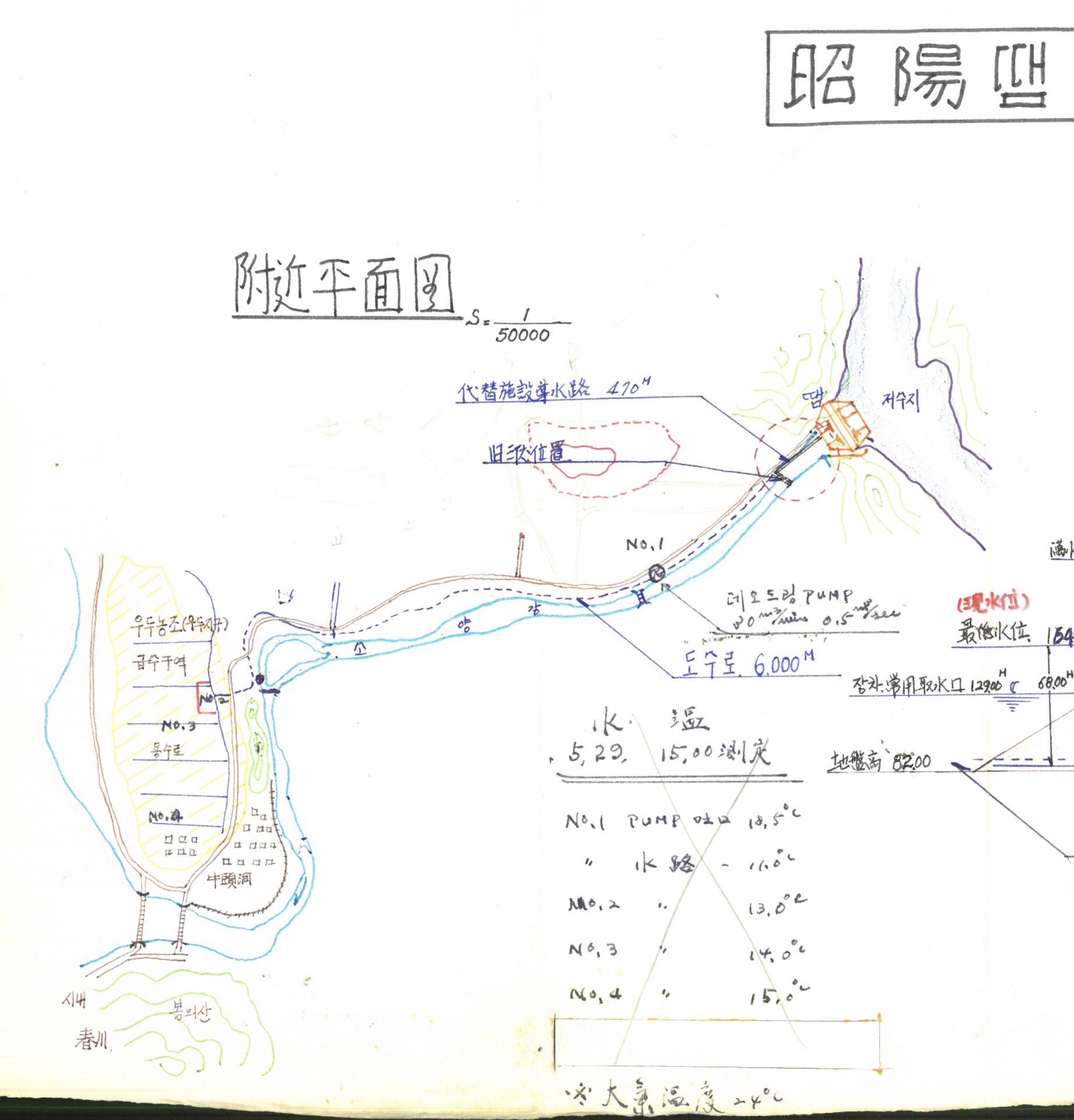
Figure 2: Detailed map of Soyang Dam (part). This hand-drawn map on the right demonstrates how water was supplied from the dam to Udu Farmland and where water temperatures were taken (No.1-No.4.) (National Archive of Korea, BA0933711, p. 11)
In addition to the changes in irrigation, a newly introduced rice variety complicated the problem. To increase rice production, the government had introduced the new rice variety Tongil (unification) in 1972 to rice fields around the country. Tongil was a fruitful outcome of South Korea’s participation in the global scientific effort during the Cold War. After the development of the first Green Revolution hybrid varieties in the 1950s, the Rockefeller Foundation and the Ford Foundation established the International Rice Research Institute (IRRI) in the Philippines. Tongil was engineered by HEU Mun Hue, a professor at Seoul National University and one of the South Korean scientists sent to IRRI. By hybridizing Japonica and Indica, the two major subspecies of rice, Heu created a variety that promised higher productivity and pest resistance. The problem was that it was more sensitive to the lower temperature than previously dominant breeds because of its genetic proximity to the tropical Indica breed.[9] A poor harvest in 1972 due to colder summer underscored this weakness.
Damage from cold water was a special concern because rice production increase was one of the most important national developmental goals set by the government. The year 1973, in particular, was designated as “the year of the decisive battle for food production increase.” The government established a nation-wide network to achieve this goal. The newly created Office of Food Production Increase Planning under the executive’s purview closely monitored the status of rice farming every month.[10] Local governments and branches of rural supervising offices educated farmers with advanced knowledge of new rice varieties, disease control, and fertilizing strategies. Rice farmers like those of the Udu Farmland Improvement Association were in charge of achieving this national goal under tight technological and bureaucratic control. Increasing rice production hinged on the success of Tongil, and so did the ideological and political success of Park’s authoritarian regime.
The local rice farmers’ petition was resolved with the construction of the Udu Water Heating Reservoir. The water would naturally warm-up before used for rice farming by storing in the reservoir for a few days.[11] On the rice fields, the cold byproduct of one technological system frustrated the other, significantly challenging the seemingly well-planned national developmental goals at the local level.
The cold water released from the dam continued to change the local environment. Most of all, it changed riverscapes and river use by the local people. Because water temperature discharged from the dam was constant year-round at 5-6°C, it cooled the river in summers and warmed in winters. Thus, recreational uses of the river, including swimming and ice-skating, was significantly limited. Some saw industrial possibilities in this new environment. In 1965, Gangwon Province received a donation of 1 million rainbow trout eggs from California to incubate and grow in the experimental hatchery under the leadership of PARK Kyung Won, the province’s governor. The cold water of the dam turned out to be an ideal environment for trout growth. With the support of the new Inland Water Fisheries Act of 1975, Soyang Multipurpose Dam not only became one of the earliest industrial rainbow trout farming sites but also became a new habitat for this foreign species as millions of trout fry were released to the lake.[12]
The local weather changed as well, as a result of the gigantic body of water created by the dam. The most significant change was the increase in foggy days. Especially in colder seasons, because water temperature remained higher than the atmosphere, more water evaporated into the air causing severe fogs and frosts. For instance, in Chuncheon city, the annual days of fog increased from 39 to 63.5, and the annual days of frost from 78.4 to 114.1 after the Soyang Multipurpose Dam was constructed—thus, the nickname “the city of fog.” With more vapor in the air, it worsened the level of air pollution as well, especially acid fogs and high particulate matter. Increased fogs would impact agricultural production and transportation, but its public health consequence was a particular concern; local doctors reported a high rate of respiratory diseases and arthritis in the city, although strong statistical evidence was hard to come by.[13]
These environmental impacts of the large dams began to be properly studied only in the 1990s. NGOs, think tanks, and scientists in Gangwon Province started to investigate the economic, infrastructural, cultural, and environmental costs of the dam to the region and how to calculate them in monetary terms. This effort to chart the negative consequences should be understood within the context of growing awareness that the dam had created and worsened regional inequality. Seoul’s urban area grew at an unprecedented rate, benefiting from Soyang Multipurpose Dam as it allowed the development of previously flood-prone land. But vast areas along the river in Gangwon Province experienced heavy regulations of land use in order to protect water resources. Gangwon Development Research Institute, the local think tank, strongly argued that local people experienced more losses than benefits. Thus, they argued, active measures were needed, including extra payments from downstream cities for water use and the investment of profits from the dam in local communities, which would “minimize the social and economic inequality.”[14] Against such claims, the Korea Water Resources Corporation, the manager of Soyang Multipurpose Dam, concluded that the damaging impacts claimed by local communities were insignificant, although they did acknowledge the necessity of increasing support to the local communities for the sake of calming the complaints.[15]
Conclusion
Can cold water from the dam have any value for the local community? In 2017, Gangwon Province proposed to turn the nuisance of cold water into a resource. By 2022, they planned to construct an industrial complex near Soyang Multipurpose Dam focusing on two high-tech industries, data centers, and smart farms. The cold water will run through these two different industrial facilities transferring heat energy from one to another; it will cool down the heat from the data infrastructure and then be used to warm up the IT-infused agriculture facilities. This “water-energy-food nexus” is expected to bring environmentally-friendly economic growth to the region that has suffered economic stagnation for many years. This plan reimagines cold water as thermal-hydro energy that would make the region “the industrial capital of the big data.” This conceptual shift about the value of coldness not only highlights the materiality of cloud computing but also how the local continuously negotiates with the envirotechnical systems.
The story of the Soyang Multipurpose Dam casts a historiographical question of how to build a narrative from the periphery. As a technology of disaster prevention and resource management, politicians and engineers envisioned the dam bringing efficient development of the lands and, thus, national economic growth. What they did not foresee was how cold water, a seemingly mundane byproduct of the large technological system, would challenge their vision. It not only challenged the other developmental goal of food production but also entirely reshaped the local communities’ relationship with the environment.
Yeonsil Kang, Ph.D. is a visiting assistant professor at Drexel University and the D. Kim Foundation Postdoctoral Fellow (2020-2021). Her research focuses on the intersections of the environment, disasters, and science and technology. She is currently working on a book manuscript Mineral Time, Bodily Time: Asbestos, Slow Disaster, and Toxic Politics in South Korea.
Suggested Readings:
Radin, Joanna, and Emma Kowal Eds., Cryopolitics: Frozen Life in a Melting World. Cambridge: The MIT Press, 2017.
Moore, Aaron Stephen, Constructing East Asia: Technology, Ideology, and Empire in Japan’s Wartime Era, 1931-1945. Stanford: Stanford University Press, 2013.
Mizuno, Hiromi, Aaron S. Moore, and John DiMoia Eds., Engineering Asia: Technology, Colonial Development, and the Cold War Order. Bloomsbury Academic, 2018.
Jeon, Chihyung, “A Road to Modernization and Unification: The Construction of the Gyeongbu Highway in South Korea,” Technology and Culture 51 no. 1 (2010): 55-79.
Ensmenger, Nathan, “The Environmental History of Computing,” History and Culture 59 no. 4 Supplement (2018): S7-S33.
Copyright 2020 Kang Yeonsil
Notes
[1] “Soyang Multipurpose Dam Opens its Floodgates for the First Time in 5 Years,” Hankyoreh August 26, 1995,17.
[2] Han River Basin Joint Survey Team. 1966. 12. A Preliminary Report on Soyang and Chungju Multipurpose Dam.
[3] Korea Engineering Consultants Corporation. 1968. Soyang River Multipupose Dam Basic Planning and Design Report. Ministry of Construction.
[4] Aaron Stephen Moore. 2013. Constructing East Asia: Technology, Ideology, and Empire in Japan’s Wartime Era, 1931-1945. Stanford: Stanford University Press.
[5] Gangwon Province. “Small-Scale Project (Water Heating Reservoir Construction, Udu Farmland Association Udu Farmland), 1973-1974.” National Archives of Korea, BA0933711, pp. 35-52.
[6] Juyoung Lee. 2015. “The National Physical Plan for South Korea and Regional Science Theory: The Practice of Planning in South Korea’s First Comprehensive National Physical Development Plan, 1963-1972.” Seoul National University, Master’s Thesis.
[7] “Farms Lost with the Disastrous Flood,” Kangwon Ilbo July 14, 1981; “The Amount of Damage from Opening of the Floodgates Amounts to 200 Mil Won,” Kangwon Ilbo July 17, 1981.
[8] Gangwon Province, “Small scale project”, 62-76; 133.
[9] Tae-Ho Kim. 2017. Social History of Rice in Modern Korea. Seoul: Deullyeok.
[10] The President’s Secretariat. 1973. “Establishment of the Office of Food Production Increase Planning.” National Archives of Korea, EA0005547(1).
[11] The construction of the Udu Water-Heating Reservoir created much disputes as well. In order to create the reservoir large enough to support the affected rice paddies, the acquisition of rice fields owned by 54 different farmers was necessary, ironically. All rice farmers initially disagreed with selling their land for its expected economic loss.
[12] Korea Trout Farmer’s Association. 2015. 50-Year History of Trout Farming in Korea.
[13] Citizen’s Coalition for Economic Justice Chuncheon Branch. 1997. Nature and Human of Soyang Lake; Seung Up Choi. 2001. The Impact of Dam Construction to the Surrounding Regions and Measures: Focusing on Soyang Multipurpose Dam. Gangwon Development Research Institute.
[14] Choi, The Impact of Dam Construction, 136.
[15] Korea Water Resources Corporation. 2013. Research on the Cost-Benefit Analysis of Social and Economic Impacts of Soyang Multipurpose Dam to the Country and the Region.