
Levees, Slavery, and Maintenance

Figure 1. Beginning of crevasse breaching levee at Mounds Landing, Miss., Great Mississippi River Flood, 1927. Courtesy of the National Oceanic and Atmospheric Administration (NOAA).
Technology’s Stories vol. 6, no. 3 – DOI: 10.15763/jou.ts.2018.08.20.01
Davis_Levees Slavery and Maintenance
Why is the U.S. Army in charge of the levees on the Mississippi River? There’s no one-sentence answer to this question. Even answering it in a paragraph would be difficult. The story of how the military became entwined with the great river goes back to arguments over the republic’s founding documents, and what amount of landscape “improvement” was appropriate for the central government. It even involves theories of construction and infrastructure developed in French military schools—debates which were ongoing before the United States was founded. The Mississippi’s catastrophic floods—occurring consistently every few years, and with distressingly increasing destructive power—generally loom as the antagonists in the story of how federal authorities gained control over the Mississippi Delta, transforming it into the enormous technical system we recognize today. The famous deluge of 1927 stands as the watershed, revealing the limits of a piecemeal system run by squabbling state levee boards and inviting the assumption that the “problem” of the Mississippi floods required an integrated solution of commensurate, military-grade scale.
But this story of flood and response elides the levee system’s basic structural flaw. Southern landscapes were built by enslaved people. Those landscapes’ continued existence was based on the notion that planters could violently compel laborers to maintain their levees and fields. The entire system was designed to rest on the backs of enslaved black workers, and an enormous amount of energy expended over centuries to mitigate the risks inherent to this precarious system. When levees failed (and continue to fail), this component of the design is often lost in the rush to blame “nature,” or in the tendency to see broken levees as artifacts of technological hubris. What is rarely considered is what C. Vann Woodward called slavery’s underlying “curse to the soil.”[1] So why is the inescapable legacy of slavery often left out of the saga of the federal government assuming control of the Mississippi? Slavery’s absence is a symptom of a larger failure in U.S. history to account for its brutal past. But a report of a steamboat trip at the end of the Civil War, and a file of complaints assembled by the military occupation in the army’s engineering archive may provide new insight into this already complicated history. Though previously ignored, in a full account, slavery plays a central role in the narrative of federal infrastructure.
A few days after Christmas, 1865, Maj. Henry L. Abbot of the Corps of Engineers received orders to head to Memphis and find passage on a steamboat southward from there to New Orleans. His job was to examine the levees lining the Mississippi’s banks and to compile a report on what it would take in terms of repairs to prevent catastrophic failure and widespread destruction to southern crops when the springtime floods came. That Christmas was the first peacetime holiday Americans had enjoyed after four years of brutal and bloody warfare. Combatants in the Civil War had indeed cut or demolished levees strategically over the course of intense fighting in places like the former Confederate stronghold at Vicksburg, Mississippi. But Abbot anticipated the majority of the damage to the levee system would be due to neglect.
Had his river cruise taken place before the war, Abbot would have seen work gangs of slaves toiling on both the levees and the fields beyond. Levees required extensive upkeep, and were under constant surveillance for seepage and weakness. Planters tasked their slaves with hauling clay for structural reinforcement, tending the grassy slopes, clearing clogged sluices and ditches, and cutting trees whose root systems would damage the levees’ structural integrity. Doing this hard and dangerous work, these gangs would have been clearly visible to any observer on a riverboat deck. But from reports he received, Abbot was skeptical that he would see any activity on the levees—even if they remained standing and had not been reduced to watery waste. His fears would soon be confirmed: entropy and the South’s prolific vegetation took their toll on the thousands of miles of structured embankments that kept cotton fields dry and productive. Aboard the steamer Flora in Memphis soon after the new year, Abbot wrote to his network of military and civilian engineers throughout the Delta, alerting them to his project and asking their assistance as he began creating his catalog of destruction.[2]
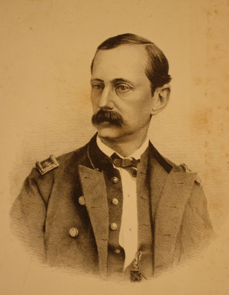
Figure 2. Maj. Henry L. Abbot, ca. 1880-1890. MS Am 1447 (15), Houghton Library, Harvard University.
Abbot was no stranger to the Delta. He had spent the better part of the decade before the Civil War in and around the lower Mississippi floodplain, making a minute study of the Delta environment. Andrew Humphreys, soon to be chief of the U.S. Army’s engineer bureau, had handpicked Abbot, bringing the young engineer eastward from his previous duties on the Pacific Railway Survey and installing him as his right hand in Louisiana. The famous Report on the Physics and Hydraulics of the Mississippi River, published just before the outbreak of hostilities in 1861, lists Humphreys and Abbot as co-authors. In reality, Humphreys supervised his protégé from Washington, as Abbot undertook many years of fieldwork—surveying, sounding, and digging geologic core samples—that furnished the data for the Report’s conclusions. Although the war’s intervening years had dramatically changed both these men and the nation, Abbot found himself ordered back to the delta under similar circumstances.[3]
Like many West Pointers of his generation, Abbot saw himself as a scientist as well as a soldier. Soon after its publication Abbot had sent complimentary copies of the Report to fellow scientists across the United States, and carefully preserved the notes of praise he received back from Charles Eliot and Benjamin Peirce, then colleagues in the mathematics department at Harvard College.[4] Although the equations for discharge of an open-channel stream Humphreys and Abbot developed from Dubuat’s work and published in their Report would turn out to be flawed, the amount of geographical and hydrological data they gathered mark the Report as a major milestone in American science. Writing it also caused Abbot to come to see the entire Delta as one vast, interlocking, and precarious system—one constantly under threat of complete disintegration should the required inputs of energetic maintenance flag.
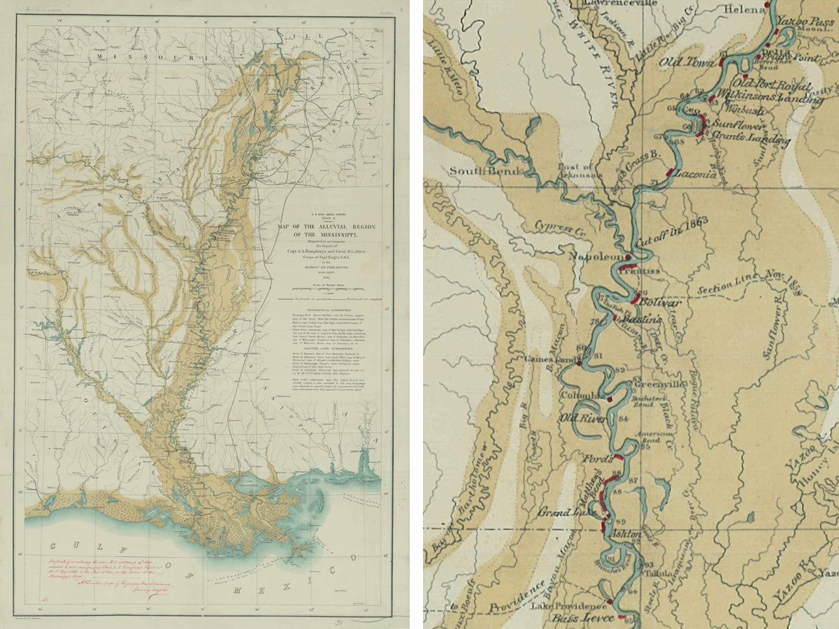
Figure 3. Map of the Alluvial Region of the Mississippi with Abbot’s mss. markups. National Archives, College Park, Maryland.
“The river is looking very badly,” wrote Abbot from aboard the steamer Magenta on his way back up to Memphis after his initial survey, with characteristic dispassionate understatement. Abbot carried a copy of the delta survey map with him on his riverboat cruise, marking where levees had failed and large crevasses formed leaving the adjacent farmland defenseless. The map, a clean copy of which is in the National Archives, shows the sinuous form of the Mississippi River covered in red ink. Significant breaches several miles in width seem to stretch along the river every few miles. Abbot struggled to convey the true magnitude of the destruction, making lists of waterlogged places with names like Chamber’s Levee, Vermillion Lake, Robinson and Chinon Levee, Hockpockana, and Matthew’s Bend, and hiring local teams to branch out and survey areas that he lacked the time to set eyes on himself. [5]
By the time Abbot arrived in New Orleans around mid-January, 1866, panic had already set in. State levee officials, planters, and cotton factors from the Crescent City upstream to New Madrid watched with mounting dread as the days slipped away and the March and April floods drew irresistibly nearer. Piecemeal attempts at financing and organizing work parties to repair breaches had only added to the chaos. Abbot surveyed this with a professional detachment, as his written orders, folded and tucked into his diary, explicitly forbade any extended federal entanglement:
It is not the intention of the War Department to enter into an extended system of repair of the levees or the construction of new works but merely to make temporary repairs of old levees at points where repairs are most urgently required, and where if not made the danger of great injury to agriculture is imminent….[6]
Alhough threatened with complete ruin, Abbot’s response would have to be ad hoc and constrained.
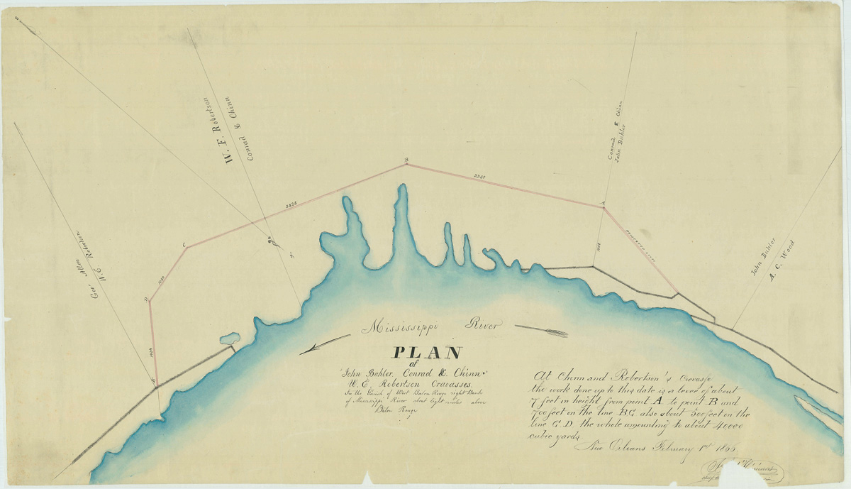
Figure 4. Plan of John Buhler, Conrad L. Chinn, W. E. Robertson Cravasses [sic], in the Parish of West Baton Rouge right Bank of Mississippi River about eight miles above Baton Rouge, February 1866. National Archives, College Park, Maryland.
A year later, the 1867 floods wrecked the patchwork and made new destructive inroads into the prewar levees. Knowing now that sending one engineer in a steamboat down river was an insufficient gesture in the face of the waterlogged region, Reconstruction military authorities instead activated their network of occupation units, who fanned out over the countryside to put together a picture of the disaster. Col. C. H. Smith, commander of the Arkansas sub-district, circulated a document soliciting reports on the flooding throughout his domain in April 1867. Over the spring and early summer he received a flood of responses from Freedmen’s Bureau agents, state engineers, and planters, each outlining the devastation to their counties or parishes, and more often than not, floating theories and thinly-veiled accusations as to why they were subject to such suffering.
“The destruction and ruin are wide spread and general,” wrote a planter named Minor Merriwether from Memphis, “and many persons are leaving in heartbroken despair.”[8] A planter named Rice Dulin reported that the territory thirty miles in width between the Mississippi and Arkansas rivers was “inundated all.” “The old levees have mostly caved in,” he continued, “and our private levees broken and washed down.”[9] Alfred Eddington observed that where he lived in Desha County, Arkansas, “[o]ccasionally there is a small piece of the levee left standing.” Eddington was sure to note in his letter to the federal military commander that a worryingly large crevasse had developed: “it is not very long; but is quite deep—it is about 300 yards long and looks like a small river.”[10]
The planters generally agreed that the rise of the “private” levee system after 1840 had put them in this predicament. Some planters grumbled about the increasing population and cultivated acreage in the Upper Mississippi, which they perceived as shunting more and more water downstream to bear on their levees. The 1850 Swamp Lands Act was a favored scapegoat, and at least one state engineer resentfully brought up the Moon Lake Break, cut by the federal army in 1863, that “in this county does more damage than all the others put together.”[11] But blaming the Yankees was largely a mask for an underlying resentment of how the levee system worked. Planters were ultimately responsible for the levees at the riverbank of their property. In a complicated system of assessments and standards, state levee boards organized taxation and hired engineers to set standards for state-wide levee maintenance. But enforcement was nearly impossible and state engineers had limited jurisdiction; for example, Louisianans often complained about the lax standards of Arkansas levees just north of the political boundary.
The real burden however was financial. Antebellum planters could pay their levee tax in labor, forcing their enslaved laborers to work on their levees and extinguishing their tax burden with the sweat of their slaves. That’s how the system worked in the cash-poor South before the Civil War. With their slaves freed by Emancipation, the planters exhibited a myopic stubbornness when they insisted that the way cotton production was protected should remain the same. “Thus, the freedmen, (almost universally interested in the crop on shares),” wrote Thomas Smith, owner of Meckatro Plantation, in a revealing rant to the Reconstruction authorities,
cannot be made to understand, or look to the disastrous results of an overflow, & their employers have no power to command their labor for levee purposes, although their crop may depend on its protection…. However important it may be, individuals have not the means, + cannot apply the plantation labor…[12]
Blaming recalcitrant labor, Smith saw no alternative to the destruction of the entire cotton-producing region except a massive financial bailout from the federal government.
Smith was like many planters in that he failed to see that the world had changed, preferring instead to fight like hell to recreate the antebellum order. His casting of freedmen as ignorant and lazy was typical of white men of his social class in the Reconstruction South. In reality, freedpeople were asserting political power and refusing to do the brutally difficult and dangerous work done previously under threat of the lash, or worse. Across the South freedpeople refused “mud work” of this kind without commensurate wages, causing paroxysms of rage among the planter class, who obstinately felt entitled to the labor of black men and women to sustain the precarious landscape they had created and profited from.[13]
Southern planters had created a vast and sinister maintenance regime, and within a few years of gaining their freedom, the freedpeople had dealt that system a devastating blow. It was, however, not fatal. White southerners worked hard to undermine Reconstruction’s social project, yet retain northern enthusiasm for capital improvements and a willingness to invest in cotton infrastructure. Southern states had sought federal financial and technical assistance with the Mississippi levees since the republic’s infancy; the war and “the failure of labor” however gave them a new avenue of approach, allowing them to rhetorically lay the salvation of their landscapes at the federals’ feet. “I hope that the Government will do something to reclaim this country,” wrote Merriwether in what was a common refrain. “It is too valuable to give up to a wilderness, and the people there are utterly prostrated. This flood has extinguished the last glimmering hope of protection, and starvation is looking them in the face.”[14] These enticements were precisely the sorts of entanglements Abbot’s orders had warned about. Full federal control would come in 1927, but federal involvement was akin to a slow process of accretion. A Mississippi River Commission with permanent seats for federal military engineers was established in 1879, and the landmark 1899 Rivers and Harbors Act further consolidated federal authority over all navigable waterways. Whatever reluctance Abbot’s superiors had toward becoming involved in the levees at the end of the war soon faded into obscurity.
In the following years, Abbot became a vocal advocate for replacement of the slave-maintained system with a sophisticated network of data collection stations and control structures under federal control. “[T]here must be a general system throughout the valley,” he wrote in 1870 to his superiors in Washington.[15] Abbot’s experiences in the postwar chaos had prejudiced him against sensationalized data published in the river cities’ newspapers, and the limited perspective of the “popular” view of construction, maintenance, and regulation amidst the hundreds of miles of squabbling authorities strung along the river’s edge.[16] Abbot came to see the only viable way to keep the valley functioning was to replace the accursed components of the original system with engineered federal standards of construction and maintenance.
The original conception of the Mississippi Delta as a carceral landscape, held together by coerced labor, curtailed any ability to imagine a radically different technical environment.[17] A potent ideological mix of white supremacy and cotton fever underlay antebellum infrastructure, still in force after the war, as white southerners sought to naturalize their agricultural and social organization through a focus on property rights and racial hierarchy. The Mississippi Delta to this day bears the engineered fruit of a highly capitalized cotton extraction regime—one in which the planters transformed into capitalists, capital and landholdings remained concentrated, and life didn’t get much easier for black Americans. But for a brief moment during Reconstruction there were furtive attempts at imagining radical land reform abetted by the engineering structures that were deemed necessary for the basin’s continued human inhabitation. Abbot and a Reconstruction congressman from Missouri named Benjamin F. Loan informally consulted on using portions of the rebuilt levees to reclaim lands for freedmen’s colonies. A year after the floods, Loan asked Abbot to look into how much swampland would be affected by a proposed Memphis and St. Louis Railroad Company levee, running along the western bank of the Mississippi from Cape Girardeau to the mouth of the St. Francis River. Abbot calculated that the “work’s shadow” protected from flooding would yield a 6,900 square mile “elliptical district” behind the 200-mile-long levee. With a “thorough general system and a great good judgment in details,” he argued, the federal government could have provided a vast tract of settlement for freedmen that would have dwarfed the Sea Island and Davis Bend experiments. But Loan was defeated in the 1868 elections, and Abbot filed away his plans in his personal papers.[18]
Inhabitants of the Delta today remain in the shadow of these works whose provenance lie in the murky nightmare of the cotton and slavery that forms the foundation of both the United States and global capitalism. We would do well to remember this inextricable legacy when criticizing the design of particular elements of the system, or grimly resolving to further and further reinforce and solidify infrastructures whose seeming permanence and inevitability obscure the circumstances under which they were originally built. It is helpful to know where the burden of maintaining these levees comes from, as they grow and grow to increasing heights, and their long historical shadow remains dark.
Davis – Levees, Slavery, and Maintenance
Recommended Readings
Baptist, Edward E. The Half Has Never Been Told: Slavery and the Making of American Capitalism. New York: Basic Books, 2016.
Nelson, Megan Kate. Ruin Nation: Destruction and the American Civil War. Athens, Ga.: University of Georgia Press, 2012.
Pabis, George S. “Subduing Nature through Engineering: Caleb G. Forshey and the Levees-Only Policy, 1851-1881.” In Transforming New Orleans and Its Environs: Centuries of Change, edited by Craig E. Colten, 64–83. Pittsburgh: University of Pittsburgh Press, 2000.
Parrish, Susan Scott. The Flood Year 1927: A Cultural History. Princeton and Oxford: Princeton University Press, 2017.
Reuss, Martin. “Andrew A. Humphreys and the Development of Hydraulic Engineering: Politics and Technology in the Army Corps of Engineers, 1850-1950.” Technology and Culture 26, no. 1 (1985): 1–33.
Shallat, Todd A. Structures in the Stream: Water, Science, and the Rise of the U.S. Army Corps of Engineers. Austin: University of Texas Press, 1994.
Shallat, Todd. “Water and Bureaucracy: Origins of the Federal Responsibility for Water Resources, 1787-1838.” Natural Resources Journal 32, no. 1 (Winter 1992): 5–25.
Strickland, John Scott. “‘No More Mud Work’: The Struggle for the Control of Labor and Production in Low Country South Carolina, 1863-1880.” In The Southern Enigma: Essays on Race, Class, and Folk Culture, edited by Walter J. Fraser, Jr. and Winfred B. Moore, Jr., 43–63. Westport, Conn.: Greenwood, 1983.
[1] C. Vann Woodward, Origins of the New South 1877 – 1913 (Baton Rouge: Louisiana State University Press, 1970), 180.
[2] Gen. Andrew A. Humphreys to Maj. Henry L. Abbot, December 26, 1865, 1865 Journal, Box 1, Henry L. Abbot Papers, MS Am 1447, Houghton Library, Harvard University, Cambridge, MA (hereafter cited as HLAP); Abbot to Capt. Henry A. Pattison, January 2, 1866, Letters and Telegrams Sent, Civil War and Mississippi Duty, 1862-1867, v. 3, HLAP.
[3] Andrew A. Humphreys and Henry L. Abbot, Report on the Physics and Hydraulics of the Mississippi River upon the Protection of the Alluvial Region against Overflow; and upon the Deepening of the Mouths: Based upon Surveys and Investigations Made Under the Acts of Congress Directing the Topographical and Hydrographical Survey of the Delta of the Mississippi River with Such Investigations as Might Lead to Determine the Most Practicable Plan for Securing It from Inundation, and the Best Mode of Deepening the Channels at the Mouths of the River (Philadelphia: J. B. Lippincott, 1861).
[4] Benjamin Peirce to Abbot, December 29, 1861, Folder 3, Box 8, Henry Larcom Abbot Family Papers, Manuscripts Division, Library of Congress, Washington, D.C.; Charles W. Eliot to Abbot, January 17, 1862, ibid.
[5] Abbot to Humphreys, February 2, 1866, Letters and Telegrams Sent, Civil War and Mississippi Duty, 1862-1867, v. 3, HLAP.
[6] Humphreys to Abbot, December 26, 1865.
[7] Abbot to Pattison, January 2, 1865, Letters and Telegrams Sent, Civil War and Mississippi Duty, 1862-1867, v. 3, HLAP; Abbot to Humphreys, January 6, 1866, ibid.; Abbot to Gen. E. R. S. Canby, January 11, 1866, ibid.; Abbot to Humphreys, May 11, 1866, ibid.
[8] Minor Merriwether to Maj. Miles McAlester, April 22, 1867, Box 17, Letters Received 1865-1870, Entry 25, Correspondence of the Office Divisions, 1865-1870, Correspondence, 1869-1870, Records of the Office of the Chief of Engineers, Record Group 77, National Archives Building, Washington, D.C. (hereafter cited as Smith Letters).
[9] Rice Dulin to Col. C. H. Smith, July 29, 1867, Smith Letters.
[10] Alfred A. Eddington to Capt. J. C. Proudmore, May 24, 1867, Smith Letters.
[11] Daniel J. Murphy to Proudmore, May 27, 1867, Smith Letters; William Hewson to Col. William E. Merrill, August 15, 1867, Smith Letters.
[12] Thomas Smith to C. H. Smith, September 1, 1867, Smith Letters.
[13] John Scott Strickland, “‘No More Mud Work’: The Struggle for the Control of Labor and Production in Low Country South Carolina, 1863-1880,” in The Southern Enigma: Essays on Race, Class, and Folk Culture, ed. Walter J. Fraser, Jr. and Winfred B. Moore, Jr. (Westport, Conn.: Greenwood, 1983), 43–63.
[14] Merriwether to McAlester, April 22, 1867, Smith Letters.
[15] Abbot to Gen. John Parke, April 20, 1870, Official and Personal Letters, June 10, 1867 – April 20, 1870, Box 9, HLAP.
[16] Abbot to Humphreys, March 2, 1870, ibid.
[17] Walter Johnson, River of Dark Dreams: Slavery and Empire in the Cotton Kingdom (Cambridge, Mass.: Belknap Press of Harvard University Press, 2013), 209–43.
[18] Benjamin F. Loan to Humphreys, January 17, 1868, Box 1, Letters Received 1871-1886, Entry 71, Correspondence of the River and Harbor Division, Records of the Office of the Chief of Engineers, Record Group 77, National Archives Building, Washington, D.C.; Abbot to Humphreys, January 31, 1868, Official and Personal Letters, June 10, 1867 – April 20, 1870, Box 9, HLAP.